Aug. 26, 2020
As of Wednesday morning, Hurricane Laura had sustained winds of 125 mph. Laura has become much more organized and is exhibiting several traits of a major hurricane.
The National Weather Service has characterized Laura’s storm surge as “unsurvivable” and could produce destructive waves that could cause catastrophic damage from Sea Rim State Park, Texas, to Intracoastal City, Louisiana, including Calcasieu and Sabine Lakes. This surge could penetrate up to 30 miles inland from the immediate coastline. Hurricane-force winds are expected tonight in portions of the hurricane warning area from San Luis Pass, Texas, to the west of Morgan City, Louisiana, with catastrophic wind damage expected where Laura’s eyewall makes landfall.
Hurricane-force winds and widespread damaging wind gusts will spread well inland across portions of eastern Texas and western Louisiana early Thursday.

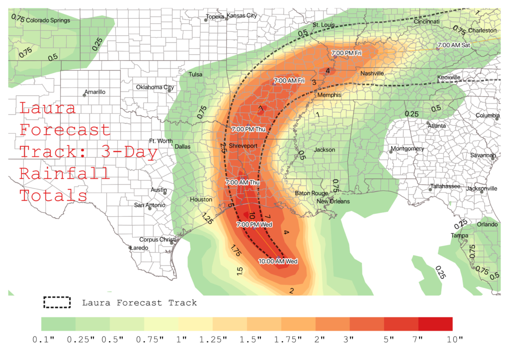
Many in the path of the storm are taking preparedness actions including moving cattle to higher ground. In the direct path of the storm, the Texas counties of Sabine, Jasper, Newton, Orange, and Jefferson have between 70 and 80 thousand cattle and calves. These counties could see 10+ inches of rainfall over the next couple of days. Widespread flash flooding along small streams, urban areas, and roadways is expected to begin Wednesday afternoon into Thursday from far East Texas, across Louisiana and Arkansas.
Laura is likely to continue strengthening Wednesday as it moves through warmer Gulf waters and is expected to be a Category 4 hurricane by the time it reaches the Gulf Coast.
