This Week’s Drought Summary
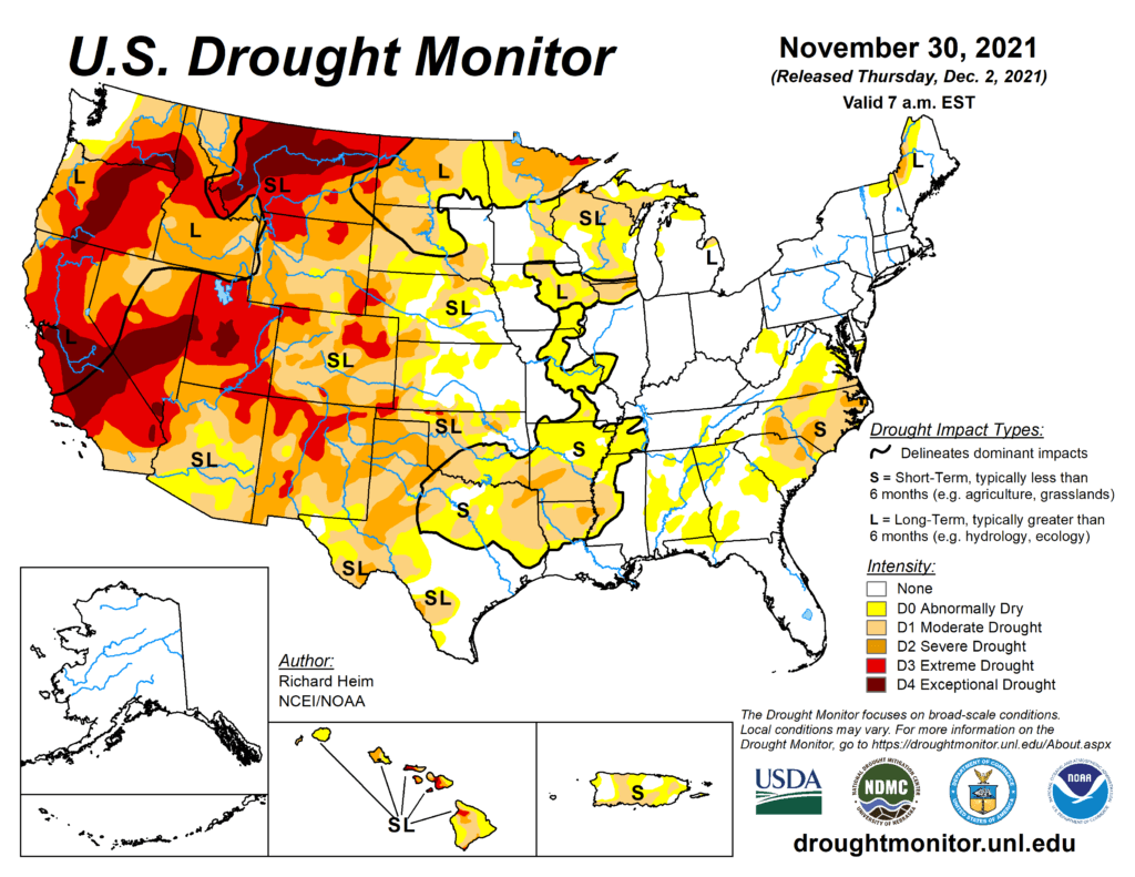
Several Pacific weather systems moved across the contiguous U.S. (CONUS) during this U.S. Drought Monitor (USDM) week. An upper-level ridge over the western CONUS directed the systems across the northern states, while a cutoff low trekked across Texas then into the Gulf of Mexico. The Pacific systems dragged cold fronts with them that stretched the width of the CONUS, from the Great Lakes to the Gulf of Mexico coast. The fronts triggered rain and snow over parts of the country, but they were starved of precipitation by the western ridge and its northwesterly flow over the central CONUS. As a result, the week was wetter than normal only in parts of the Pacific Northwest, northern Rockies, Great Lakes, and Texas. The weather was drier than normal across the rest of the CONUS with large parts of the West, Great Plains, Upper Mississippi Valley, and Southeast receiving no precipitation. Most of the West and Great Plains were warmer than normal thanks to the western ridge. The persistent above-normal temperatures contributed to excessive evapotranspiration in western portions of the Great Plains as well as parts of the West, as seen in EDDI and ESI indicators. Lack of precipitation, excessive evapotranspiration, and windy conditions further dried soils, again especially in western portions of the Plains, as seen in several soil moisture indicators. Drought indicators such as the Standardized Precipitation Index
(SPI) and Standardized Precipitation Evapotranspiration Index (SPEI) reflected the mounting precipitation deficits. The continued dryness expanded or intensified drought in parts of the southern to central Rockies, Great Plains, Lower to Mid-Mississippi Valley, Southeast, and Mid-Atlantic states, as well as Puerto Rico.
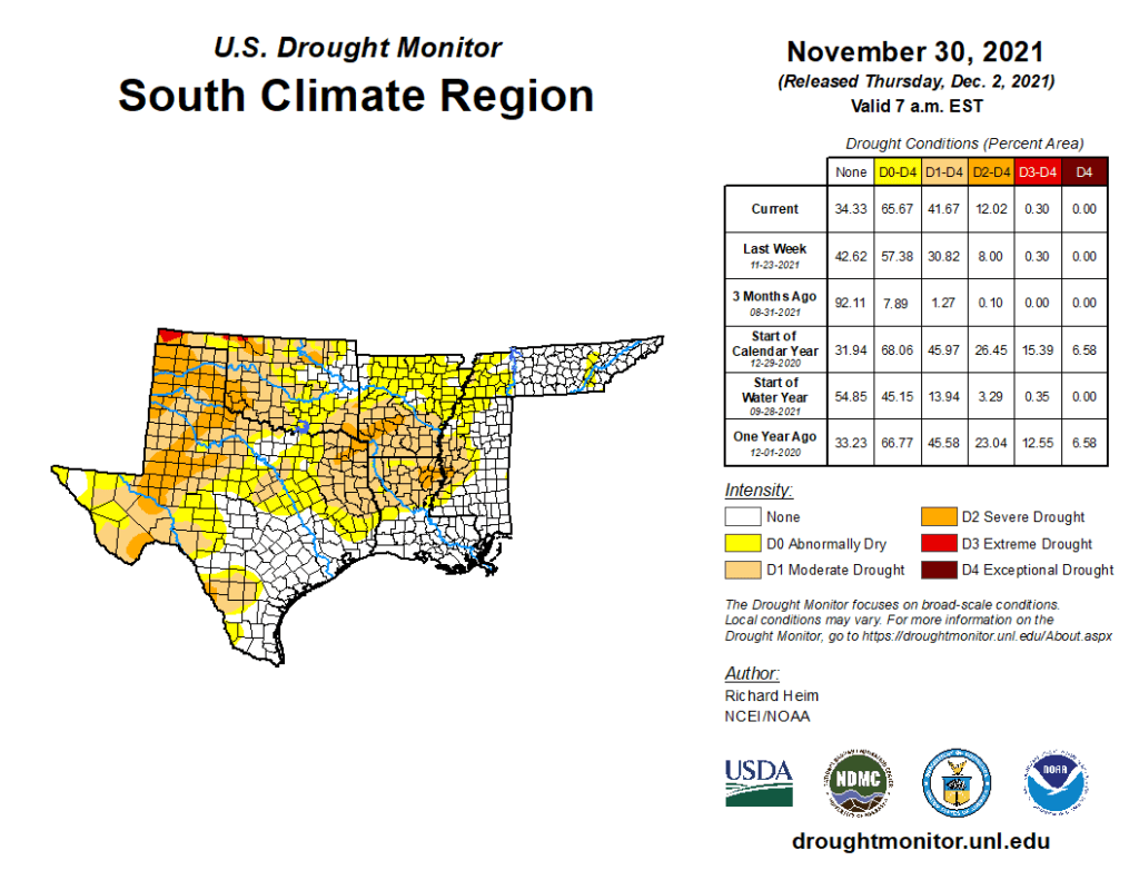
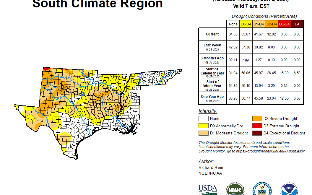
South
Half an inch to 1.5 inches of rainfall was widespread across coastal to eastern Texas, and into adjacent parts of Louisiana, and locally over 2 inches fell over parts of Texas. Smaller swaths of half an inch of rain occurred over north Texas and parts of Arkansas, Mississippi, and Tennessee. But the rest of the region had less than half an inch, with much of western Texas to most of Oklahoma receiving little to no precipitation. Moderate to severe drought contracted in a few parts of Texas where the heaviest rains fell, but much more of the state, as well as parts of Oklahoma, Arkansas, and Louisiana, saw expansion of abnormal dryness and moderate to severe drought. Areas of abnormal dryness expanded in western Tennessee and developed in eastern portions of the state. With every passing day of no precipitation, low humidity, high evapotranspiration, the wildfire threat continued to grow in Texas and Oklahoma. According to November 28 USDA statistics, 64% of the topsoil moisture in Texas was short or very short (dry to very dry) and 45% of the winter wheat crop was in poor to very poor condition. In Oklahoma, the statistics were 59% for topsoil moisture and 16% for winter wheat condition.