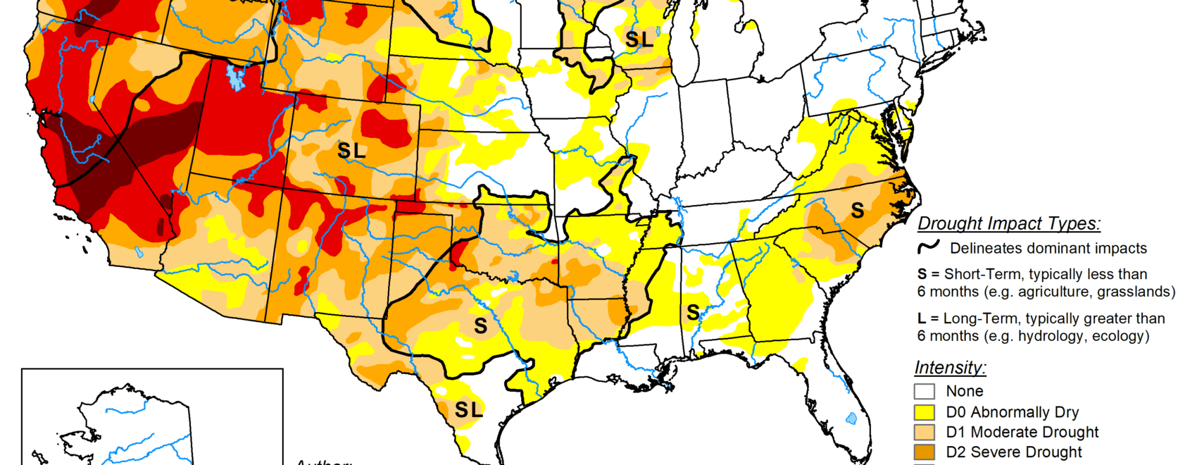
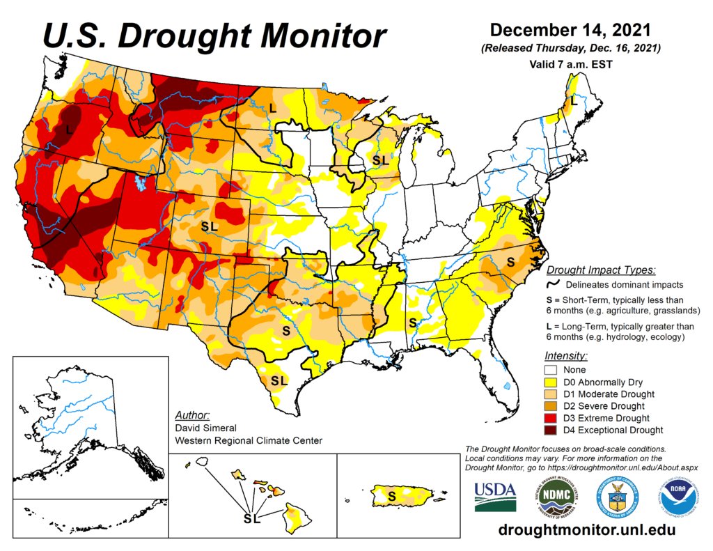
This Week’s Drought Summary
This U.S. Drought Monitor (USDM) week was marked by a much more active storm pattern across the West Coast and Northern Rockies with areas of heavy rain along the coast and valley locations. Further inland, the higher elevations of the Cascade Range, Klamath Mountains, Sierra Nevada Range, northern Great Basin, and the Northern Rockies have all received significant snowfall accumulations this week. The storm event, fueled by an atmospheric river, provided a much-needed boost to snow water equivalent (SWE) levels in the Far West. On December 14, the NRCS SNOTEL network was reporting normal-to-above-normal SWE in Oregon’s Willamette (100% of median) and Southern Oregon Coastal (116%) basins as well as in the Lower Sacramento (113%), San Joaquin (106%), Tulare-Buena Vista Lakes (119%), Truckee (137%), Carson (120%), Walker (122%) and Mono-Owens Lakes (122%) basins of the Sierra Nevada Range. In the Lower Mississippi, Tennessee, and Ohio Valley, an outbreak of violent thunderstorms including dozens of tornadoes, erupted along a path spanning from northeastern Arkansas to northeastern Kentucky. The tornados moved very rapidly through the region on Friday night with devastating effect, especially in the southeastern Kentucky town of Mayfield. In Kentucky, latest reports announced at least 74 people lost their lives, and the death toll is expected to increase. In the Mid-Atlantic, unseasonably warm temperatures were observed over the weekend with daily high-temperature records broken in Pennsylvania, West Virginia, Virginia, Maryland, Delaware, New Jersey, and North Carolina where high temperatures ranged in the mid-60’s to mid-70’s. On the map, short-term precipitation shortfalls and anomalously warm temperatures led to the degradation of drought-related conditions in portions of the Mid-Atlantic, Southeast, South, and in the Midwest, while some improvements were made in the High Plains and isolated areas out West. According to NOAA’s National Center’s for Environmental Information (NCEI), November 2021 was the 7th warmest on record for the contiguous U.S. as well as the 7th warmest January-November period on record. In terms of precipitation, November marked the 8th driest for the contiguous U.S., while year-to-date precipitation ranked in the middle third (61st wettest). At a regional level, the Rockies and Westward Region saw its warmest November (+5.8 deg F anomaly) on record as well as its warmest March-November period on record.
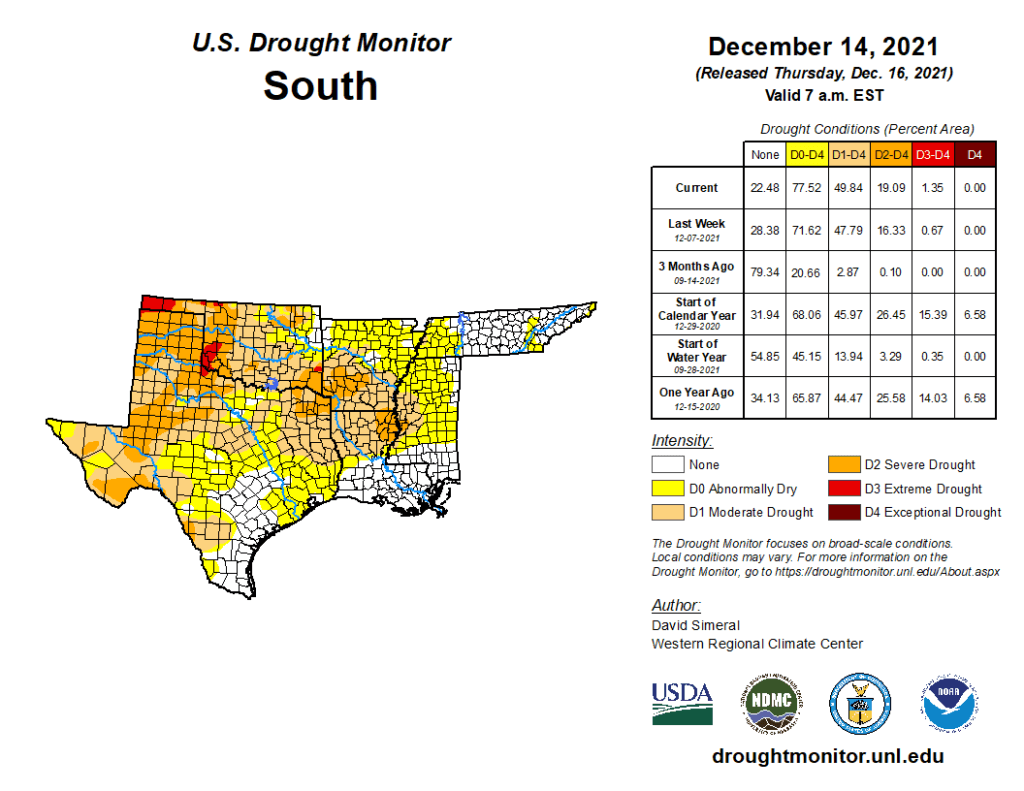
South
In the South, conditions on the map continued to degrade across areas of Texas and Oklahoma where unseasonably warm and dry conditions prevailed this week. The dry conditions showed up on a variety of drought indicators including satellite-based soil moisture and evaporative demand tools. Additionally, numerous rivers and streams in the western half of the state showed flows dipping below the 20th percentile during the past 7-day period. Rainfall deficits (ranging from 3 to 6+ inches) during the past 60-day period were greatest in southeastern Oklahoma, eastern Texas, Louisiana, and southwestern Arkansas. For the week, average temperatures were above normal (2 to 10+ deg F) across Texas, Oklahoma, Louisiana, Arkansas, and Mississippi.