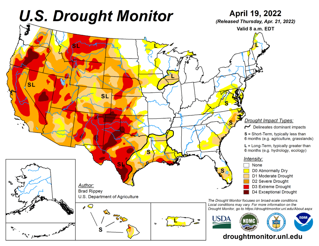
This Week’s Drought Summary
The drought-monitoring period, which began on the morning of April 12 and ended early April 19, featured a powerful spring storm delivering significant, late-season snow from the Cascades and Sierra Nevada to the northern Plains. High winds and blizzard conditions accompanied the snow, especially across the northern Plains. Farther south, drought conditions worsened across portions of the central and southern Plains and the Southwest, amid windy, dry conditions. At times, winds raised dust and contributed to the rapid spread of several wildfires, including the 6,159-acre McBride Fire, which destroyed well over 300 structures after being ignited on April 12 in Ruidoso, New Mexico. Meanwhile, heavy showers and locally severe thunderstorms swept across the Mississippi Delta and environs, producing widespread rainfall totals of 2 to 4 inches or more and causing localized wind and hail damage. Significant rain fell in other areas, including parts of the Midwest and Northeast. During the last 24 hours of the drought-monitoring period, rain swept into the Atlantic Coast States, with some wet snow observed across the interior Northeast. Warm weather prevailed for much of the period in the South and East, while a harsh cold snap engulfed the northern Plains and Northwest. In fact, an extended spell of chilly weather broadly covered the western U.S., as well as the upper Midwest.
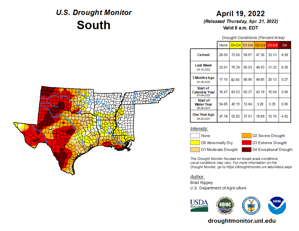
South
Heavy rain fell across roughly the eastern half of the region, resulting in extensive reductions in the coverage of abnormal dryness (D0) and moderate to extreme drought (D1 to D4). According to a network of volunteer (CoCoRaHS) observers, month-to-date rainfall totals of 6 to 8 inches or more are common across the region. April 1-19 rainfall officially reached 8.51 inches in Arkadelphia, Arkansas; 7.64 inches in Hattiesburg, Mississippi; and 6.70 inches in Troy, Alabama. In stark contrast, moderate to exceptional drought (D1 to D4) continued to worsen in many areas west of a line stretching across eastern sections of Oklahoma and Texas. On April 17, Texas led the U.S. (tied with Montana) with topsoil moisture rated 85% very short to short, according to the U.S. Department of Agriculture. Also, on the 17th, more than three-quarters (81%) of the winter wheat in Texas, along with 80% of the oats and 76% of the rangeland and pastures, were rated in very poor to poor condition. Nationally, 37% of the winter wheat was rated in very poor to poor condition on that date, highest at this time of year since April 14, 1996, when 43% of the crop fell into those two categories. On the southern High Plains, episodes of blowing dust or smoky skies have been common this spring; in Lubbock, Texas, visibilities were sharply reduced in dust on April 12, when a southwesterly wind gust to 60 mph was reported. The south-central U.S. has also experienced periods of extreme heat, with McAllen, Texas, reporting highs of 100°F or greater on April 6, 11, and 13. McAllen’s high of 109°F on April 6 set a monthly record (previously, 107°F on April 26, 1984, and April 27, 2014). However, there have also been cool spells, with Dalhart, Texas, posting a daily-record low of 22°F on April 14.