
SPONSORED CONTENT Keep updated on the latest weather trends and outlooks with your personal daily weather planner—delivered each day via email. To subscribe for this free service, click here.
Livestock Wx for Nov. 7, 2018: What’s a Modoki El Niño?
As many know, there has been a lot of talk about El Niño. Maybe almost as much as the talk about Beto. Well, maybe not, but, there is an alternate, and rarer type of El Niño that you might not be familiar with called a Modoki El Niño.
Modoki is Japanese for “same but different.” It’s sort of like that horse who one day has an easy-going temperament and the next, puts more distance between your seat and the saddle than you care for. Modoki events are a rarer subset of a regular El Niño and are marked by warmer water centered in the central Pacific and areas of cooler water off the West Coast of South America.
NASA and NOAA researchers have recently found that Modoki El Niño events could be becoming more frequent and progressively stronger.
This Winter – Traditional El Niño or Modoki?
Taking a closer look at current sub-surface SST anomalies, there seems to be a significant increase in sub-surface warm water within the central Pacific Ocean but not as much over the eastern Pacific. This could point towards a Modoki El Niño.
Why Is This Important?
Keep in mind that the jet stream is modified during an El Niño, primarily during moderate and strong events.
And there are differences, some quite significant, in the jet stream between a traditional and Modoki El Niño. The image below shows the difference in rainfall for your regular run-of-the-mill El Niño and a Modoki El Niño.
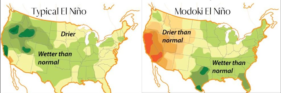
While regular El Nino events tend to bring rain to places like California, a Modoki event brings drier than normal weather. For Texas, it’s the opposite. From North Texas all the way down to South Texas, you could see an even higher chance of above-normal winter precipitation.
Bottom Line
Over the next month we will be monitoring two primary variables:
1. Sea surface temperatures as they relate to either an El Niño or Modoki El Niño events.
2. Signs of a linkage between the ocean and the atmosphere.
Right now, while most current indicators point towards a likely Modoki El Niño, climate model outlooks are inconclusive.
Pointing towards a traditional El Niño: Over the past two months, positive subsurface temperature anomalies have strengthened and expanded into the eastern Pacific Ocean.
Pointing towards a Modoki El Niño: Current sea surface temperature trends with warmest water over the Central Pacific.
Bottom Line: The nature of the weak El Niño forecast (or borderline moderate) points towards increased variability of winter season precipitation patterns — perhaps ones not fully typical of either event. Livestock Wx will continue to track conditions and will keep you updated as we move into the winter. We will also give the potential for a Modoki El Niño event further treatment in the November issue of the Livestock Weather Journal.

Texas & Southwestern Cattle Raisers Association
To Honor and Protect the Ranching Way of Life
PO BOX 101988
FORT WORTH, TX 76185
1-800-242-7820
© 2023 Texas & Southwestern Cattle Raisers Association; All Rights Reserved.