• Skip to primary navigation
  • Skip to main content
Texas and Southwestern Cattle Raisers Association

Texas and Southwestern Cattle Raisers Association

To Honor and Protect the Ranching Way of Life

  • Home
  • Who We Are
    • Why Join
    • Leadership
    • Staff
    • Partners
    • FAQs
    • Newsroom
    • Sponsorships & Advertisement
    • Employment
  • What We Do
    • Theft and Law
    • Issues & Policy
    • Education
    • Students and Young Professionals
    • The Cattleman Magazine
    • Disaster Relief Fund
    • Cattle Raisers Insurance
    • Cattle Raisers Trading Co
  • Events
    • Cattle Raisers Convention
    • Policy Conference
    • Summer Meeting
    • Ranch Gatherings
    • Ranching 101
  • Join
  • Member Center
  • TSCRA Store
  • Show Search
Hide Search

Livestock Wx for 1-24-19: Outbreaks of cold weather are coming

The Livestock Weather report for Jan. 17 takes a look at the latest seasonal outlooks for precipitation and temperatures. Livestock Wx is exclusive information on the latest weather trends and outlook for TSCRA members. How cold will our next few weeks be? And where will the rain fall?

Keep updated on the latest weather trends and outlooks with your personal daily weather planner—delivered each day via email. To subscribe to this free service, click here.

Livestock Wx for Jan. 24, 2019: Outbreaks of cold weather are coming.

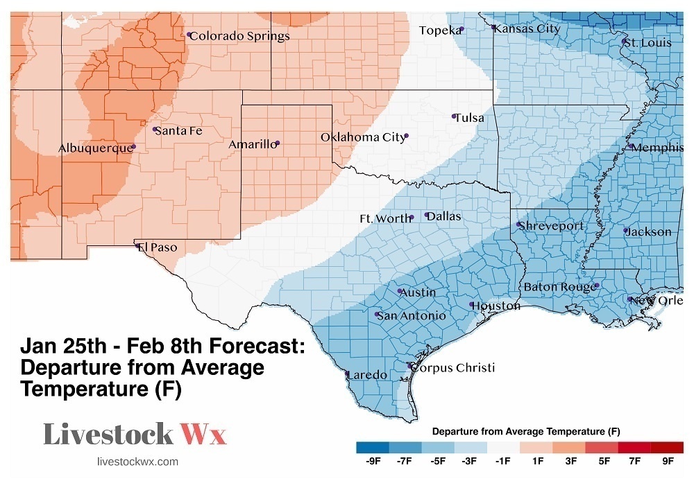
Weather outlooks are calling for unusually cold air to persist into at least the first week of February. The image below shows the departure from average temperature forecast over the next 15-days. Starting late Monday or early Tuesday (Jan. 29), temperatures will start dropping for most of OK and TX. In some cases, the average temperature could be seven degrees or more below normal. 

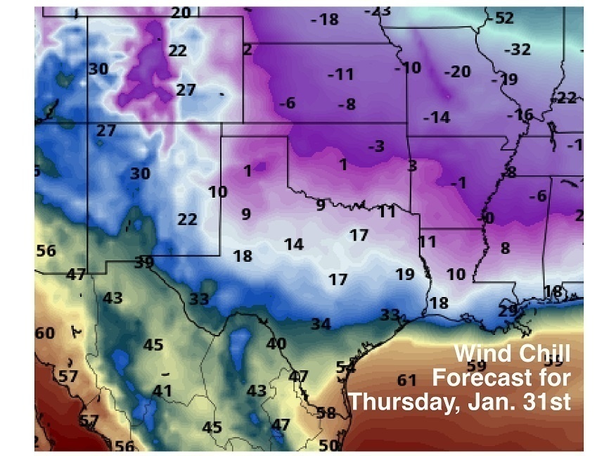
It could be worse. You could be in the Midwest or Northeast, which is expected to see the coldest temperatures. In fact, if some of the weather model runs are correct, these could be some of the coldest temperatures they have seen in years, with wind chills approaching -50F. Take these estimates with a grain of salt, however, since we are a long way out. The general trend, though, is for very cold temperatures. All the models agree we will see cold temps, it’s just a matter of how cold. The below image (from the folks at Pivotal Weather) shows potential wind chills for Thursday morning, which look to be the timing of the coldest period for our area. The cold air is primarily due to a break-down of the polar vortex, which has allowed arctic air to penetrate into the lower 48.


Rain this Weekend

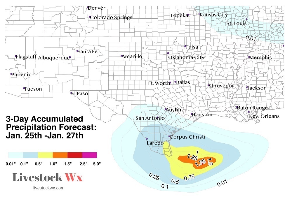
South Texas will be seeing some rain this weekend. They are currently sitting on some decent precipitation deficits so this moisture, while not a lot, will be welcome news. The image below show the 3-Day Accumulated Precipitation Forecast.

Written by:
kristin
Published on:
January 24, 2019

Categories: The Cattleman Now, The Cattleman Now - App, Weather

Recent Posts

Cattle Raisers respond to Texas cell-cultured lawsuit

January 21, 2026

FORT WORTH, Texas (January 21, 2026) — Texas & Southwestern Cattle Raisers Association President …

Continue Reading about Cattle Raisers respond to Texas cell-cultured lawsuit

Crime watch: Brown Brahman cross cow missing in Donley County

January 16, 2026

Texas & Southwestern Cattle Raisers Association Special Ranger Lynn Mays, District 2 in the …

Continue Reading about Crime watch: Brown Brahman cross cow missing in Donley County

TSCRA expands Gilly Riojas Memorial Internship Program to place top students with industry partners

January 14, 2026

FORT WORTH, Texas (January 14, 2026) — Ranches and businesses now have help finding qualified …

Continue Reading about TSCRA expands Gilly Riojas Memorial Internship Program to place top students with industry partners

Footer

Texas and Southwestern Cattle Raisers Association
  • Email
  • Facebook
  • Instagram
  • Twitter
  • YouTube

PO BOX 101988
FORT WORTH, TX 76185

1-800-242-7820

© 2023 Texas & Southwestern Cattle Raisers Association; All Rights Reserved.

COPYRIGHT | PRIVACY POLICY | TERMS OF USE