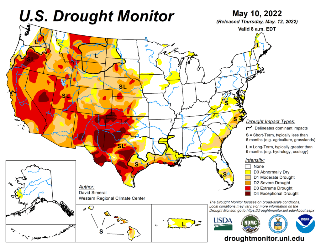
This Week’s Drought Summary
This U.S. Drought Monitor (USDM) week saw continued improvements on the map across the Pacific Northwest and the northern Plains in response to another round of unsettled weather during the past week. In the Pacific Northwest, Northern California, and the northern half of the Intermountain West, a series of disturbances starting last weekend brought cold temperatures and significant snowfall accumulations to the higher elevations of the Cascades, Klamath Mountains, Sierra Nevada, ranges of the northern Great Basin, and the Northern Rockies. Storm totals ranged from 6 to 18+ inches, providing a much-needed boost to mountain snowpack levels. In addition to the late-season snowfall, temperatures plummeted well below normal levels. Minimum temperatures dipped into the teens in the Sierra Nevada as well as across areas of the Intermountain West including Peter Sinks, Utah (Bear River Mountains of northern Utah), which registered the national low of 7 deg F on May 11, according to the National Weather Service Weather Prediction Center. In Northern California, recent storms and cooler temperatures helped to temporarily delay further deterioration of the already shallow snowpack, which was only 22% of normal statewide on May 11. In the Southwest, unseasonably warm, dry, and windy conditions exacerbated fire-weather conditions where nine large fires are currently impacting the region, including the Hermits Peak Fire which has scorched ~204,000 acres (43% contained) in the southern Sangre de Cristo Range, northeast of Santa Fe, New Mexico. In the northern and central Plains, isolated showers, and thunderstorm activity led to continued modest improvements in drought-related conditions. Meanwhile, in the southern Plains and Texas, the first heat wave of the season brought 90 to 110+ deg F temperatures to the region as well as periods of critical fire-weather conditions. In eastern portions of the southern Plains, isolated heavy rainfall accumulations (3 to 8+ inches) helped to ease drought conditions. However, drought-stricken areas of western Kansas and Oklahoma largely missed out on recent storm events. In the Midwest, light to moderate rainfall accumulations (1 to 5 inches) were observed in the southern and western portion of the region this week with most of the region remaining drought-free. In the Mid-Atlantic, rainfall accumulations ranging from 2 to 4 inches across areas of Pennsylvania, Maryland, northern Virginia, and West Virginia boosted area streamflows and helped to improve drought-related conditions on the map. In the Southeast, short-term dryness during the past 30 to 90 days led to minor degradations in the Lower Savannah River Basin along the Georgia-South Carolina border, while another round of isolated storms in southern Florida led to improvements in drought-affected areas.
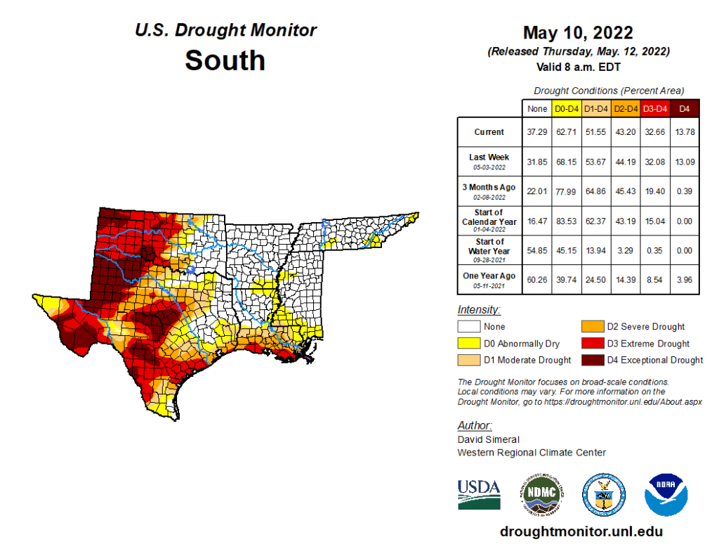
South
In the South, drought-related conditions improved in eastern Oklahoma and areas of northeastern Texas. In eastern Oklahoma, very heavy rainfall accumulations (ranging from 3 to 8+ inches) led to improvements on the map. However, this week’s heavy rains largely missed the western part of the state. Likewise, much of the western half of Texas was very dry combined with extreme heat, leading to further expansion of areas of Extreme Drought (D3) and Exceptional Drought (D4). Average temperatures across the region were well above normal. The most extreme heat was observed across Texas (6 to 10+ deg F above normal) with high temperatures soaring over 110 deg F in the Trans-Pecos region. Since last Tuesday (May 3), Big Bend Village (Big Bend National Park) logged the national high temperature six out of the seven days, with highs ranging from 102 to 112 deg F. Likewise, the heat wave that impacted much of the region saw temperatures rise above 100 deg in the southern Plains. The excessive heat this week continued to dry out already parched soils across much of Texas as well as in western Oklahoma where negative soil moisture anomalies (20th percentile) showed up on various soil moisture models. Moreover, 7-day streamflows at numerous gaging stations across the Hill Country of Texas and southwestern Oklahoma dipped below the 10th percentile, according to the U.S. Geological Survey. Also notable, Oklahoma saw its windiest April on record (1994-present) statewide, according to the Oklahoma Mesonet. According to NOAA NCEI, average temperatures were above normal across Texas, Oklahoma, and Louisiana with Texas logging its 11th warmest (+4 deg F anomaly) April on record.