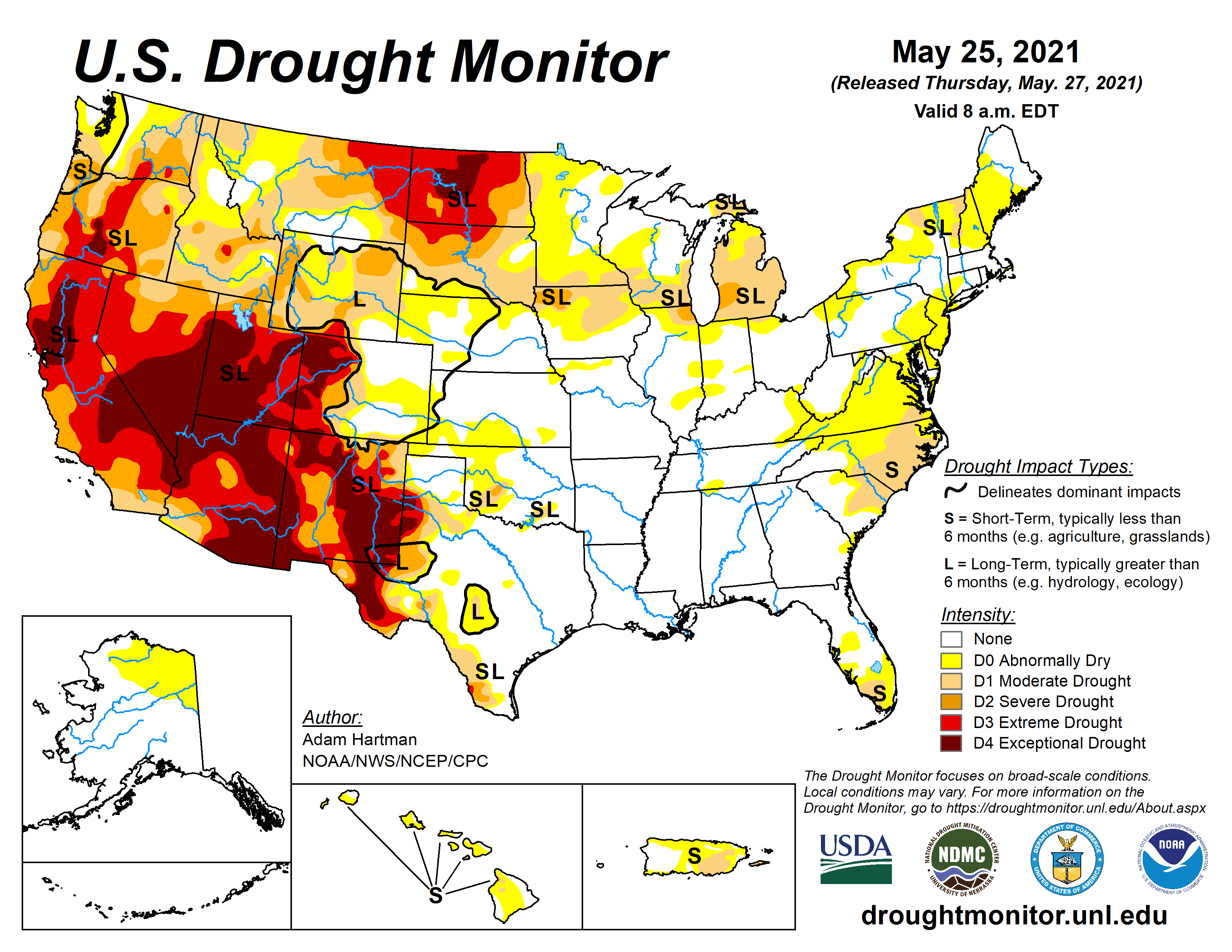
This week’s drought summary
Much of the western CONUS experienced below-normal average temperatures this week, with many areas across the Great Basin and Northern Rockies observing greater than 6°F negative departures. Above-normal precipitation in the West was limited to the high elevations of the Cascades, the Central Great Basin, Montana, and northern New Mexico. However, improvements were only warranted in western Montana and northern parts of New Mexico, where the heaviest precipitation fell. Elsewhere in the West, degradations were warranted due to declining snowpack, stream flows, and soil moisture. The Southern Plains and Gulf Coast also experienced negative 7-day average temperature departures. However, negative departures along the eastern Gulf Coast were driven by easterly to northeasterly flow early in the week whereas below-normal temperatures along the western Gulf Coast and Southern Plains were driven by above-normal precipitation (1 to 2 inches across the Southern Plains and well in excess of 3 inches through the Ark-La-Tex and along the western Gulf Coast). Heavy rains in the Southern Plains resulted in continued improvements across Texas this week, while high pressure across the Southeast exacerbated 30 to 60-day dryness in Virginia, the Carolinas, and Florida, leading to degradation of abnormally dry (D0) and moderate drought (D1) conditions. From the Central and Northern Plains eastward to the Atlantic Coast, most areas experienced temperatures 6°F to 9°F above-normal. Heavy rains fell across western portions of the High Plains Region, warranting minor improvements across the western Dakotas, while the larger improvements were observed from western Nebraska and Kansas westward to the Front Range. From the eastern High Plains Region to the Great Lakes, improvement and degradations were observed based on where the heaviest precipitation fell. In the Mid-Atlantic and Northeast, below-normal precipitation over the past couple of weeks and above-normal average temperatures this week resulted in D0 expansion from the Great Lakes to New England and into the Mid-Atlantic, with some D1 expansion in Upstate New York. Stream flows and soil moisture continue to rapidly decline across the Northeast, Mid-Atlantic, and portions of the Southeast.
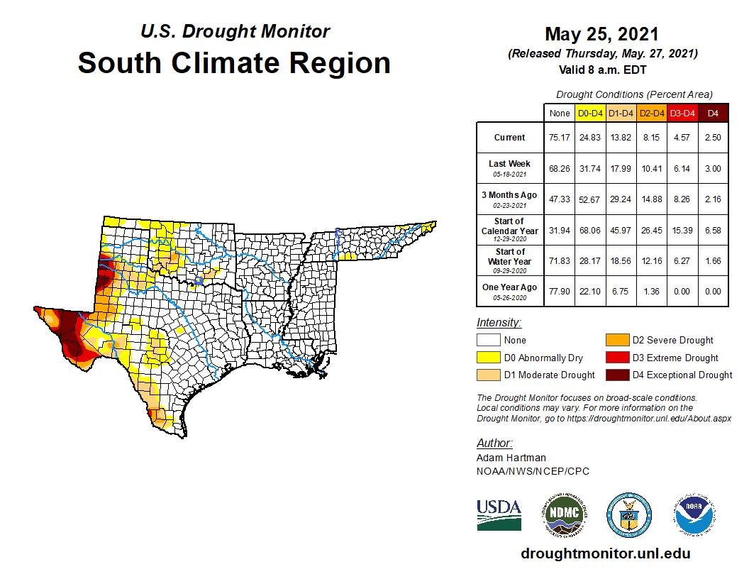
South
Heavy rainfall and flooding was the main concern for many locations in the Southern Region this week. Across eastern and southern Texas, the Ark-La-Tex, and southwestern Louisiana, many areas received in excess of 3 inches of rainfall this week, in addition to the heavy rainfall observed in recent weeks. Southeastern Texas and southwestern Louisiana were again some of the hardest hit areas, with several areas receiving 8 to 10 inches of rainfall, and more in some locations. The eastern half of Texas, although having become drought free this week, has switched to become excessively wet, with flooding ongoing in several areas. Farther west in Texas, further reductions in D0 (abnormally dry) and drought (D1-D4) coverage were warranted in areas receiving more than 2 inches of rainfall, and some green-up has been indicated across parts of western Texas in recent weeks. From northern Mississippi to central Tennessee, 30-day rainfall deficits are beginning to increase. D0 was introduced in south-central Tennessee, extending across into northwestern Alabama, as 30-day SPIs have fallen into the D0 to D1 range, despite near normal stream flows. This area also shows up well (D0 to D1 equivalent depictions) in the NASA SPoRT 0-100 cm soil moisture.