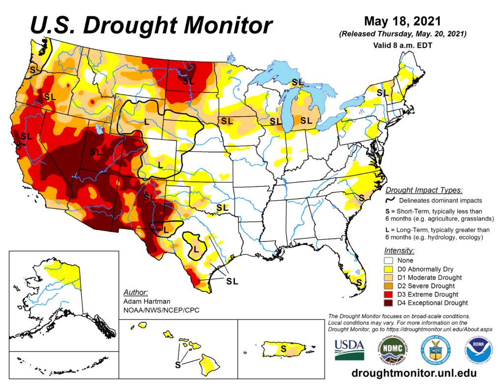
This week’s drought summary
Troughing over the western CONUS and ridging over the East resulted in strong southerly flow over the Southern and Central Plains, leading to widespread heavy rainfall (0.5 to 3 inches, and more) over portions of the Great Plains, Lower Mississippi Valley, and into western areas of the Corn Belt this week. The heaviest precipitation fell over southeastern Texas and southern Louisiana, where some locations received over 10 inches of rainfall. The heavy rainfall resulted in widespread removal and improvement in drought conditions from the Front Range eastward to Nebraska and Kansas, and southward to the Mexico border. Unfortunately, the moisture was unable to make it farther north than Nebraska, resulting in continued degradations across the Northern Plains, Upper Midwest, and Great Lakes. The Northeast experienced below normal precipitation, but due to below normal temperatures and near-normal precipitation over the past 30-60 days across much of the region, only minor changes to abnormally dry (D0) areas were warranted in southeastern Pennsylvania. In the Southeast, portions of Virginia and North Carolina have continued to dry out over the past 90 days, warranting D0 expansion. Locally heavy rainfall (2 inches) also fell over areas experiencing abnormally dry and moderate drought (D1) in South Carolina and Florida, leading to some modifications in those locations based on rainfall 7-day rainfall totals. The La Nina signal in the West was evident in the precipitation totals at the end of the climatological wet season in March. The presence of this antecedent dryness has resulted in much below-normal snowpack throughout much of the West, leading to continued drought deterioration since the region began its transition into a climatologically drier time of year during April.

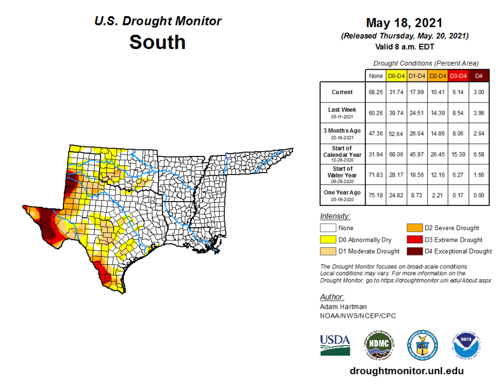
South
Heavy rainfall and flooding was the main concern in many areas of the Southern Region. Across eastern Texas, the Ark-La-Tex, and southern Louisiana, many areas received in excess of 3 inches of rainfall. Southeastern Texas and southern Louisiana were the hardest hit areas, with several locations receiving up to, and exceeding, 10 inches of rainfall. On Monday, the National Weather Service issued flood warnings in the Lake Charles, Louisiana area, where 11 inches of rain fell in a 6-hour period. Near Baton Rouge, Louisiana, locations east, southeast, and south of the city picked up nearly 12 inches of rainfall Monday night into Tuesday. Farther west in Texas, large reduction in drought coverage was warranted in areas receiving over 2 inches of rainfall. Some locations in southern Texas picked up 5 to 10 inches of rain, warranting 2 to 3-category improvements and removal in the drought depiction. From northern Mississippi to central Tennessee, 30-day rainfall deficits are beginning to increase. This area remains drought free this week, but bears watching if deficits continue to increase.
Looking ahead
During the next 5 days (May 20 to 24), the Southern and Central Plains, much of the Corn Belt, and Northern Tier states are favored to remain wet. Temperatures are also forecast to remain below-normal for much of the period across the Northern Tier. High pressure is expected to dominate over the eastern U.S., coinciding with little to no rainfall and above-normal temperatures. The Southwest and Coastal California will likely remain dry also. However, temperatures are favored to remain below-normal, moderating to near-normal as the week progresses toward Tuesday.The CPC 6-10 day extended range outlook (valid from May 25 to 29) favors above normal temperatures across the eastern U.S. and Central and Southern Plains, with enhanced probabilities in the Southeast. Above normal temperatures are also favored over northern and western Mainland Alaska, with above-normal probabilities extending to the eastern Aleutians. Below-normal temperatures are favored from the Pacific Northwest eastward to the Dakotas. Above-normal precipitation is predicted across the Southern and Central Plains, Corn Belt, and Lower Great Lakes. In Alaska, odds tilt toward above-normal precipitation for the Southwest Mainland, Eastern Aleutians, and along the South Coast to the Northwest Panhandle. Below-normal precipitation is favored in the Southeast U.S. and along the East Coast, with enhanced probabilities in the Deep South and Florida. Below-normal precipitation is also favored for the Central Pacific Coast, Great Basin, and Eastern Rockies to the High Plains.
Read more at https://droughtmonitor.unl.edu/CurrentMap.aspx
