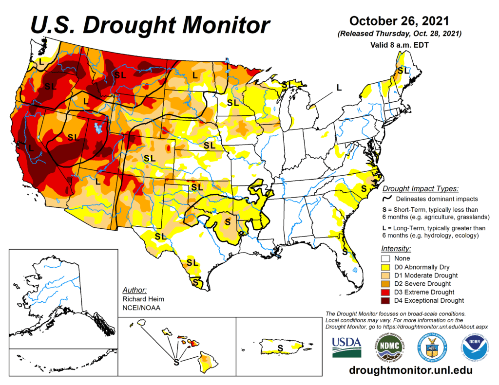
This Week’s Drought Summary
A series of strong Pacific weather systems moved across the contiguous U.S. (CONUS) during this U.S. Drought Monitor (USDM) week. The first system early in the week spread precipitation across Wyoming to the Upper Mississippi Valley, then left scattered showers over the Northeast before moving off into the Atlantic. The second brought precipitation to northern California and the Pacific Northwest. Its surface low weakened as it crossed the Rockies, but it was re-energized over the Plains and generated precipitation across the central Plains, Great Lakes, and Northeast. The third system slammed into the West Coast near the end of the week. Fed by an atmospheric river of Pacific moisture, its surface low and front left heavy precipitation across California with widespread rain and some high elevation snow from California and the Pacific Northwest to the Great Basin. According to the National Weather Service Weather Prediction Center, as the third low pressure system approached the Pacific Northwest coast, it set a pressure record, testifying to the strength of the system. The October 24th pressure was 942.5 mb, which is a record low pressure for the Pacific Northwest. The end result of these weather systems was above-normal precipitation for the week across much of the West, including the Pacific Northwest, California, Nevada, and the central to northern Rocky Mountains; across eastern portions of the northern and central Plains, the southern Great Lakes, and western and southern portions of the Northeast; and a band of precipitation from southeast Kansas to eastern Kentucky. The precipitation improved short-term conditions, especially in the West, with soil moisture, streamflow, and 1-month to 6-month Standardized Precipitation Index (SPI) indicators sliding into the wet categories. Other drought indicators, such as vegetation-based VHI and VegDRI, were slower to respond. Groundwater, reservoir levels, and longer-term (9-month to 72-month) SPI indicators still indicated very dry long-term drought conditions in the West and northern Plains. The rest of the CONUS was drier than normal, with little to no precipitation falling across much of the Southwest, central and southern Plains, Lower Mississippi Valley to Southeast, northern reaches of the Upper Mississippi Valley, and northern Maine. Weekly temperatures were warmer than normal in the Pacific Northwest to northern and central Rockies, the southern Plains to Gulf of Mexico coast, and along the eastern seaboard. Temperatures averaged cooler than normal in California and the northern Plains to Upper Mississippi Valley. Drought contracted or was reduced in intensity in parts of the West and Midwest, but expanded or intensified in the southern Plains, central High Plains, and Southeast.
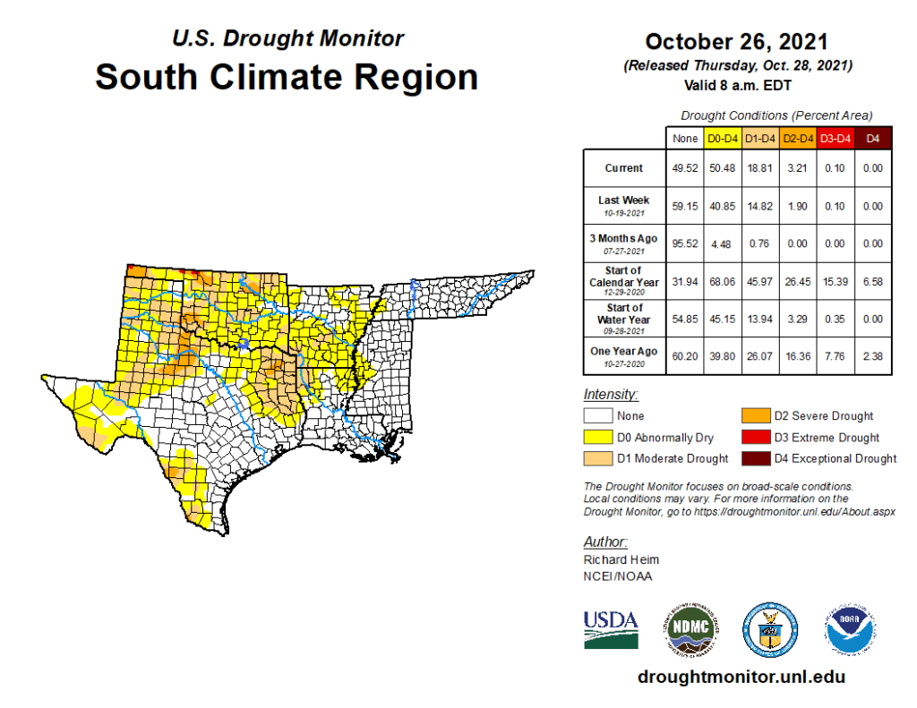
South
Temperatures were hot this week in the South, with some record high temperatures recorded in Louisiana. Parts of northern Tennessee received an inch or more of precipitation, and patches of half an inch occurred over parts of central Arkansas, southern Mississippi, and coastal southeast Texas. Otherwise, most of the South received no precipitation this week. Drying soils and vegetation prompted expansion of D0 and D1 from the ArkLaTex region to west-central Mississippi. D0, D1, and D2 (severe drought) expanded in parts of eastern, northern, and southern Texas.