This Week’s Drought Summary
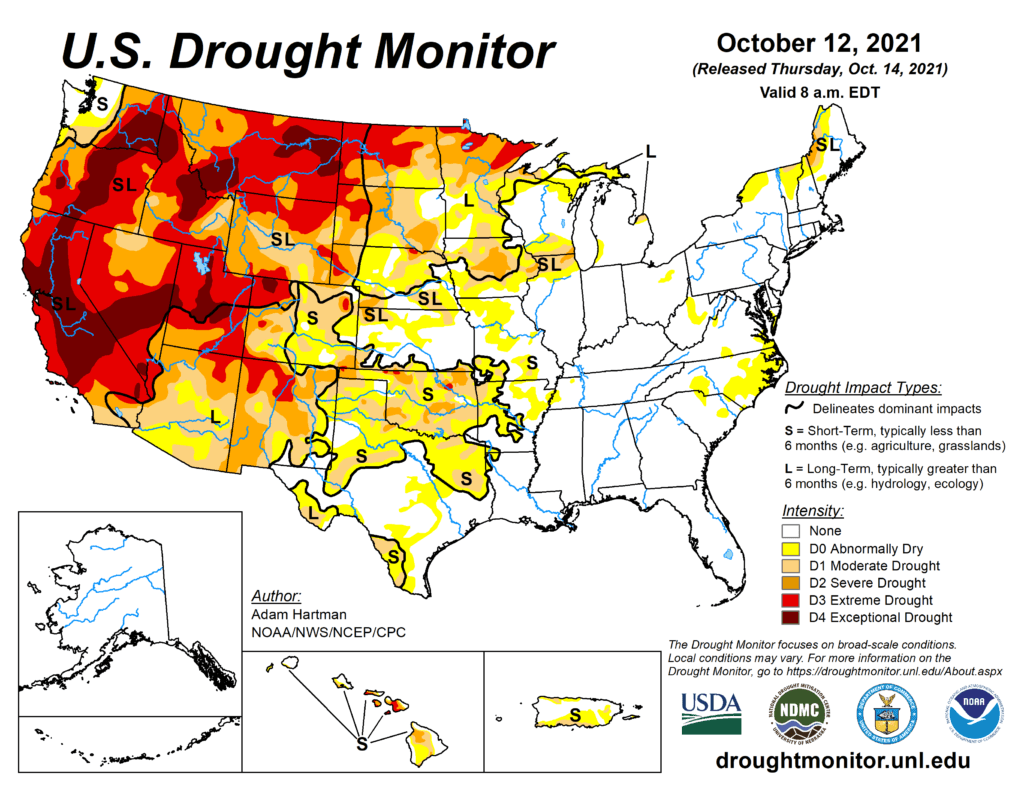
A long wave trough resulted in seasonal to below-normal temperatures across the western third of the contiguous U.S. (CONUS). A ridge of high pressure dominated the eastern two-thirds of the CONUS leading to above-normal temperatures, with the highest positive anomalies across the Northern Plains and Midwest. Despite the amplified ridge in the East, early in the week an upper level low pressure system drifted slowly northward from the Southeast to the Great Lakes bringing unsettled weather and keeping many areas across the Southeast and Ohio Valley wet. A coastal low pressure system along the coastal Carolinas brought some additional precipitation to coastal and inland areas of the Carolinas, leading to mixed reductions and expansion in coverage of abnormal dryness across the Carolinas and Virginia. In the Northeast, little to no precipitation fell and above-normal temperatures, coupled with long-term deficits, led to degradation and expansion of abnormally dry and severe drought areas across Upstate New York and New England. The Northern Plains and Upper Midwest experienced some of the largest positive temperature anomalies (8-10°F above normal) this week. However, a strong surface low pressure system brought heavy rainfall across the Dakotas and northern Minnesota, leading to broad 1-category improvements. In the wake of this storm system, a surface low pressure system developed in the lee of the Rockies over the Southern Plains dropping several inches of rainfall, further improving drought conditions (1-category improvements) in areas affected by the recent rapid onset and intensification of drought during September. As this low pressure system moved across the Midwest later in the week, it led to further improvements across portions of the western Corn Belt, due to heavy rainfall. Areas that missed out on the rainfall over the Great Plains experienced worsening conditions due to above-normal temperatures and high winds increasing evaporation and leading to increased soil moisture loss. An active storm track in the West, associated with a long wave trough, resulted in improving conditions along fringe drought areas in the Pacific Northwest and the Four Corners, where antecedent wetness leading up to this week resulted in more immediate improvements. Given the intensity and duration of drought across the remainder of the West, more precipitation will be needed to warrant more meaningful improvements.
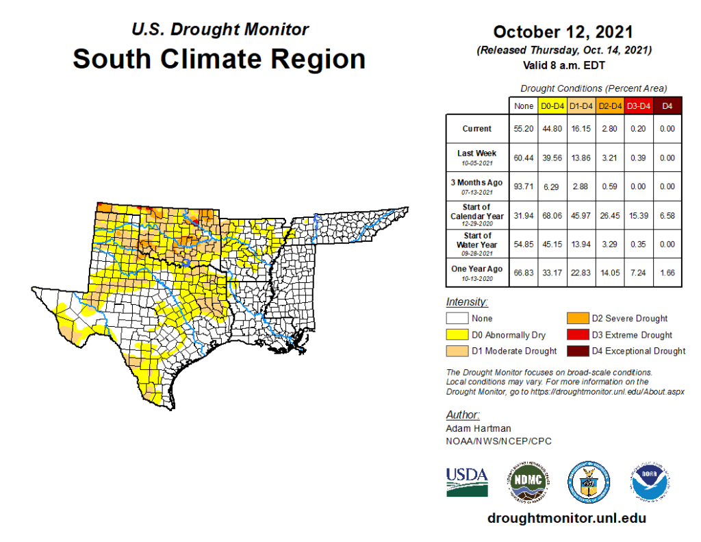
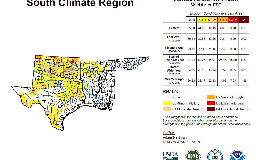
South
Ahead of a long-wave trough across the western U.S., an area of low pressure developed over the Southern Plains, bringing with it much needed precipitation to areas affected by the rapid onset of drought conditions in recent weeks. This has helped to improve conditions, mainly across parts of Oklahoma, where many locations received 2-3 inches of rainfall (greater than 1 inch positive weekly anomalies). Unfortunately, many locations outside of Oklahoma in the Southern Region continued to see further degradation and expansion of drought conditions in, and adjacent to, areas where the rains did not fall or was insufficient. Worsening conditions were observed across Texas and the Ark-La-Tex region were exacerbated by above-normal temperatures and high winds leading to increased evaporation and evapotranspiration rates.