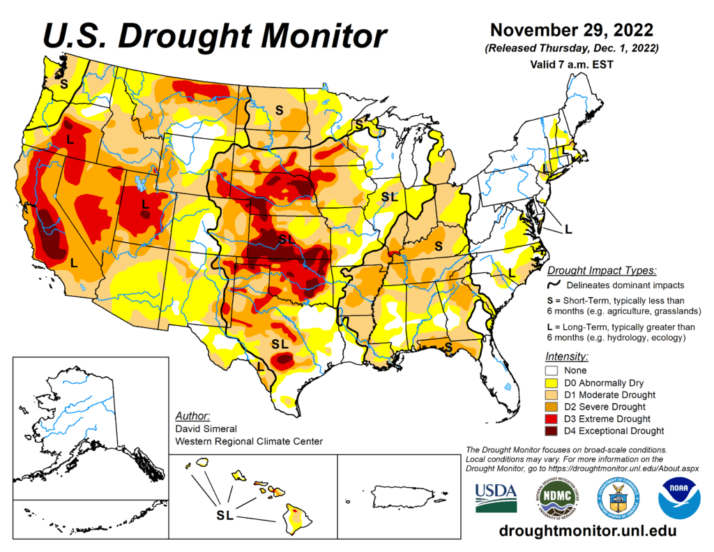
This week’s drought summary
This U.S. Drought Monitor (USDM) week saw areas of moderate to heavy rainfall along the central and western Gulf Coast region as well as areas further inland in the eastern half of Texas, southeastern Oklahoma, and southwestern Arkansas. In these areas, targeted improvements were made in drought-affected areas. Additionally, an outbreak of severe weather, including severe thunderstorms with tornadoes and wind damage, impacted areas of the South (Louisiana, Mississippi, and Alabama) overnight on Tuesday (Nov 29), resulting in severe damage and loss of lives reported. In the Southeast, isolated heavy rainfall accumulations led to improvements on the map in areas of Alabama, Georgia, and North Carolina. Elsewhere in the Southeast, short-term dryness over the past 90 days led to expansion of areas of severe drought in the Florida Panhandle, where rainfall deficits ranged from 3 to 9+ inches. In the Northeast, only minor changes were made on the map in areas of eastern Massachusetts and Rhode Island in response to precipitation shortfalls during the past 30–60-day period as well as below-normal streamflow activity and lack of groundwater recharge in areas of Cape Cod. In the Midwest, areas of moderate drought expanded in southern Michigan and northern Illinois where short-term precipitation deficits are negatively impacting soil moisture and streamflow levels. In the High Plains, generally dry and warmer-than-normal temperatures (2 to 10+ deg F above normal) prevailed across much of the region during the past week. Out West, drought-related conditions improved in areas of Arizona, New Mexico, Nevada, Washington, Colorado, Wyoming, and Montana. In terms of snowpack conditions in the region, the Natural Resources Conservation Service (NRCS) SNOTEL network is currently reporting the following region-level (2-digit HUC) snow water equivalent (SWE) percentages of median for the date (Nov 29): Pacific Northwest 134%, California 135%, Great Basin 157%, Lower Colorado 152%, Upper Colorado 98%, Rio Grande 76%, Arkansas-White-Red 66%, Missouri 101%, and Souris-Red-Rainy 81%. Looking back at the last several months, the contiguous U.S. experienced its 8th warmest September-October period on record since 1895 in terms of average temperatures (+2.2-deg F anomaly) and maximum temperatures (+2.6 deg F), according to NOAA National Centers for Environmental Information (NCEI). Precipitation in the contiguous U.S. during the September-October 2022 period ranked as the 11th driest (-1.14-inch anomaly).
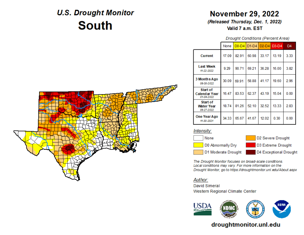
South
In the South, improvements were made across areas of the eastern half of Texas, southeastern Oklahoma, western Arkansas, and southern Mississippi where locally heavy rainfall accumulations (3 to 8+ inches) were observed. Despite this week’s rainfall in portions of Texas, streamflows in the Hill Country remain below normal with numerous gauging stations reporting levels in the bottom 10th percentile, according to the USGS. In terms of reservoir storage in Texas, monitored water supply reservoirs statewide are currently 69.9% full, according to Water Data for Texas. Some low reservoir storage levels are currently being observed in the western half of the state, including at Medina Lake (west of San Antonio) which is currently 6.7% full. According to NOAA NCEI, the South Climate Region experienced its 13th driest (-2.34-inch anomaly) September-October period on record, with Louisiana observing its 6th driest (-4.35–inch anomaly) for the contemporaneous period.