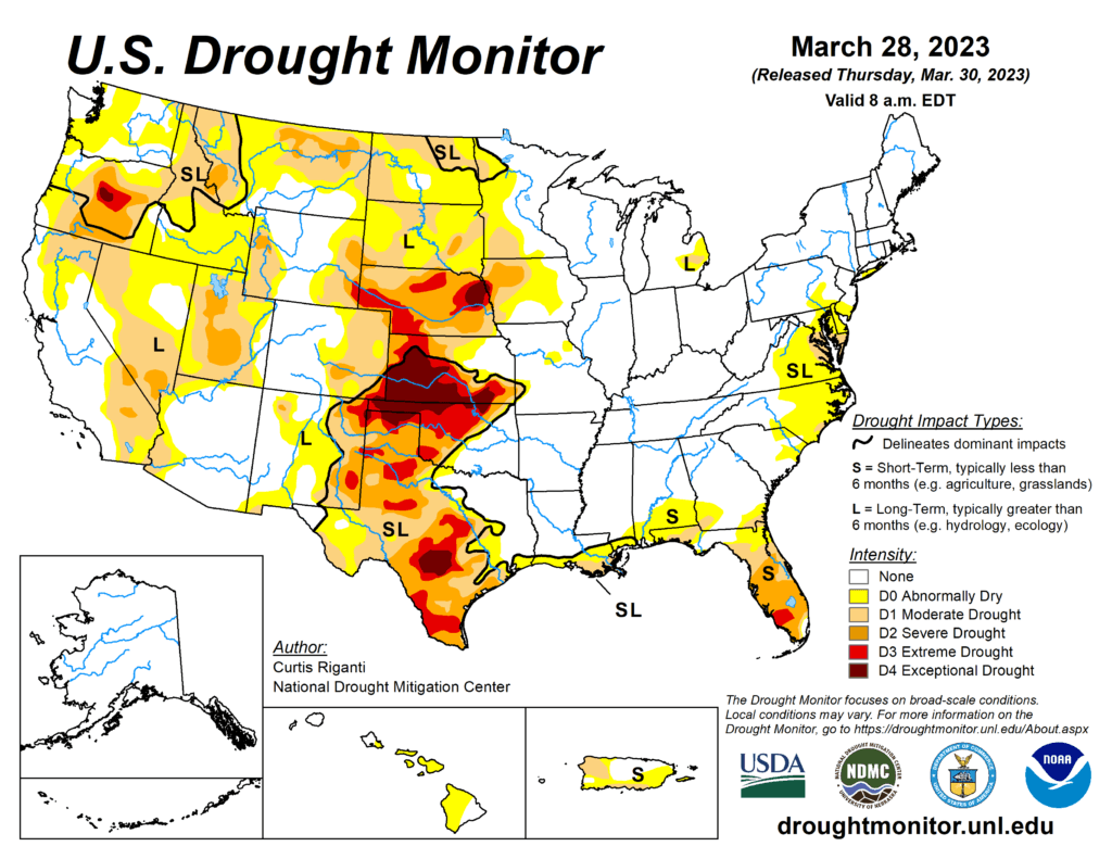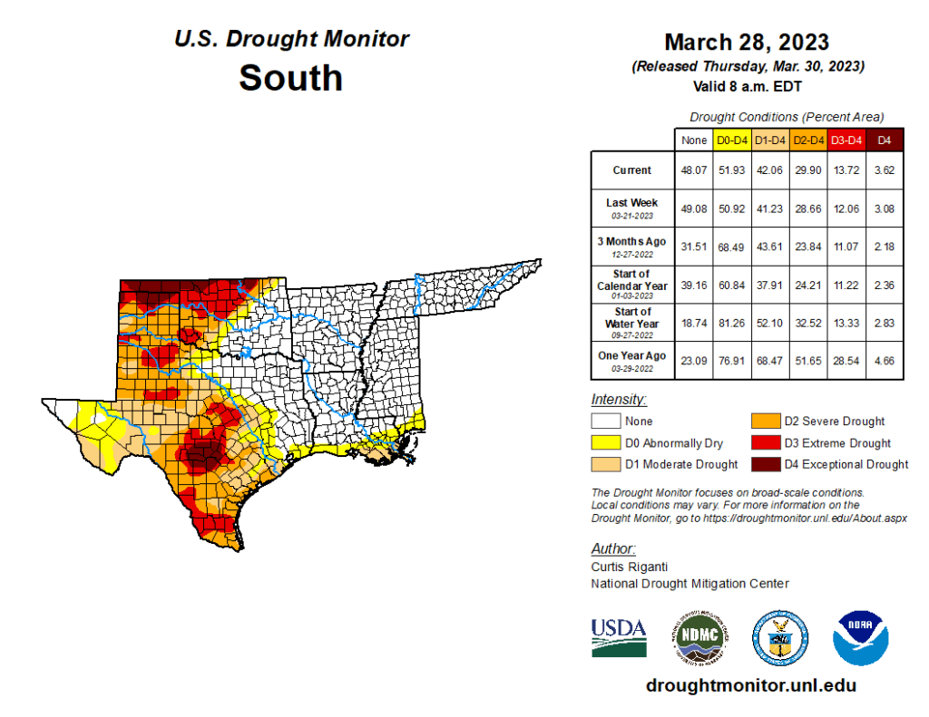
This week’s drought summary
After the wet pattern continued in parts of the West this week, building off of widespread wet and snowy weather this winter, widespread improvements were made to the drought depiction, especially in northern California, northern Nevada, southern Idaho and Utah, with scattered changes, mostly improvements, also taking place in other western states. East of the Rockies, drought and abnormally dry conditions mostly stayed the same or worsened in the Texas and Oklahoma panhandles, northwest Oklahoma, and central and southeast Texas. The western edge of heavy rains this week fell mostly along and southeast of the Interstate 44 corridor in Oklahoma and western north Texas, leading to further tightening of an already tight drought condition gradient in these areas. Farther west in northwest Oklahoma and western Kansas, extreme and exceptional drought persisted or intensified. Very dry recent weather continued in the Florida Peninsula, where severe drought expanded in coverage and extreme drought developed in response to quickly increasing fire danger. In the Mid-Atlantic, short- and long-term drought and abnormal dryness grew a bit in coverage this week. Conditions also worsened in northwest Puerto Rico and the southern Puerto Rico coast, the latter of which reported nearby forest fires. For more specific details, please refer to the regional paragraphs below.

South
Aside from Oklahoma and southwest Texas, near-normal or warmer-than-normal temperatures were common across much of the South region, with some locations seeing temperatures 5-10 degrees warmer than normal. Parts of north-central Texas and Oklahoma (especially southeast of Interstate 44) saw moderate to heavy rain amounts from thunderstorms, exceeding an inch or two in a few spots. Over 2 inches of rain fell across large areas of Arkansas and Tennessee, while heavier rains farther south in Louisiana and Mississippi were more scattered in nature. Some of this rainfall was associated with a severe thunderstorm outbreak, which was responsible for a destructive tornado that reached a maximum intensity of EF4 in Rolling Fork, Miss. Most of the rest of Texas, and Oklahoma northwest of Interstate 44, remained mostly or completely dry. The recent dry weather, very low groundwater and streamflow and mounting long-term precipitation deficits in central Texas and parts of the Edwards Plateau led to the expansion of moderate, severe, extreme and exceptional drought in some areas. Short-term dryness and decreasing streamflow also led to expanding drought conditions farther east in Texas, except for areas that saw heavier rain amounts this week. Short- and long-term extreme and exceptional drought also increased in coverage in the Texas Panhandle, the Oklahoma Panhandle and parts of northwest Oklahoma, the latter of which has recently experienced blowing dust and sand and a struggling winter wheat crop. Along the Interstate 44 corridor, the gradient in drought conditions increased further, with areas west of Oklahoma City experiencing extreme drought, while southern suburbs of Oklahoma City are only abnormally dry now, with dryness-free conditions nearby to the southeast.
