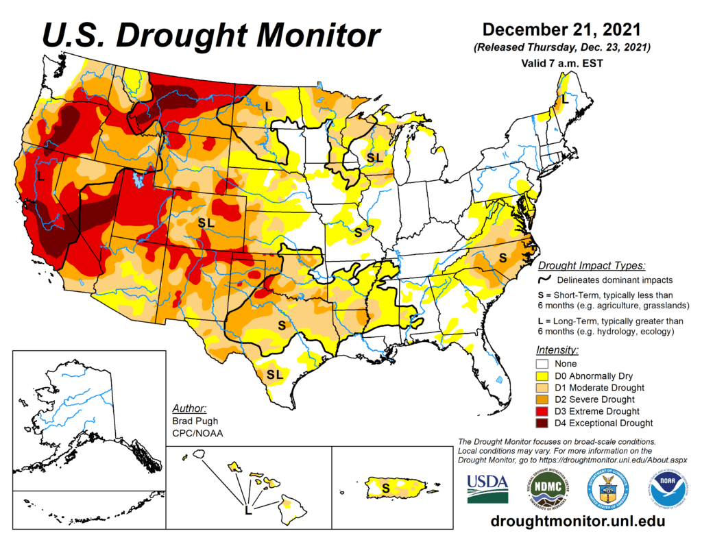
This Week’s Drought Summary
On December 14, a strong mid-level low pressure system progressed inland into southern California where heavy precipitation (0.5 to 3 inches, liquid equivalent) occurred. As this area of mid-level low pressure continued to track eastward, a powerful surface low developed across the high Plains with a subsequent track northeastward to the upper Mississippi Valley. This intense low surface low resulted in widespread damaging winds and a dust storm across the central and southern Plains. The high winds and antecedent dryness contributed to a number of wildfires across Kansas, Oklahoma, and the Texas Panhandle. According to the Storm Prediction Center preliminary data, nearly two dozen tornadoes were reported across eastern Nebraska and Iowa on December 15. As this storm tracked northeast to the upper Mississippi Valley, widespread precipitation (0.5 to 2 inches, liquid equivalent) fell over this region with heavy snow blanketing northern Minnesota. A slow-moving cold front resulted in a widespread area of rainfall (0.5 to 3 inches) from the Ozarks Region south to the western Gulf Coast. On December 18, a wave of low pressure developed along the front which led to rainfall (0.5 to 3 inches, locally more) overspreading the Southeast. However, this rainfall remained south of the increasingly dry Mid-Atlantic. A series of low pressure systems and frontal passages resulted in 7-day amounts of 0.5 to 1.5 inches, liquid equivalent, throughout the Northeast. Periods of enhanced onshore flow continued to bring rain and high-elevation snow to the Pacific Northwest and northern Rockies through mid-December. The heaviest 7-day precipitation (2 to 5 inches, or more, liquid equivalent) was observed along and west of the Cascades in Oregon. Month-to-date temperatures (Dec 1-20) have averaged more than 6 degrees F above normal across the central and southern Great Plains. In contrast to the above-normal temperatures throughout nearly all of the central and eastern continental U.S. so far this month, temperatures have averaged below normal across most of California. Following the heavy precipitation associated with a Kona low earlier this month, enhanced trade winds continued to maintain a fairly wet pattern for Hawaii through mid-December. More than 1 inch of rainfall occurred across northeast Puerto Rico from December 14 to 20.
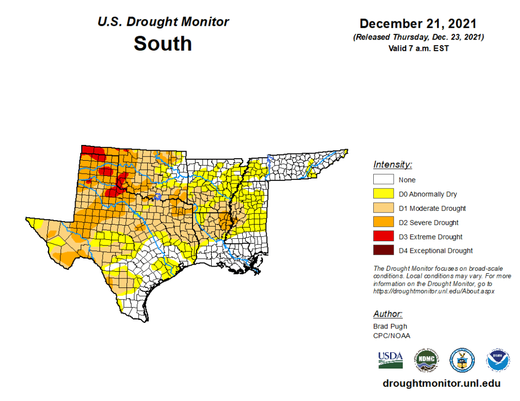
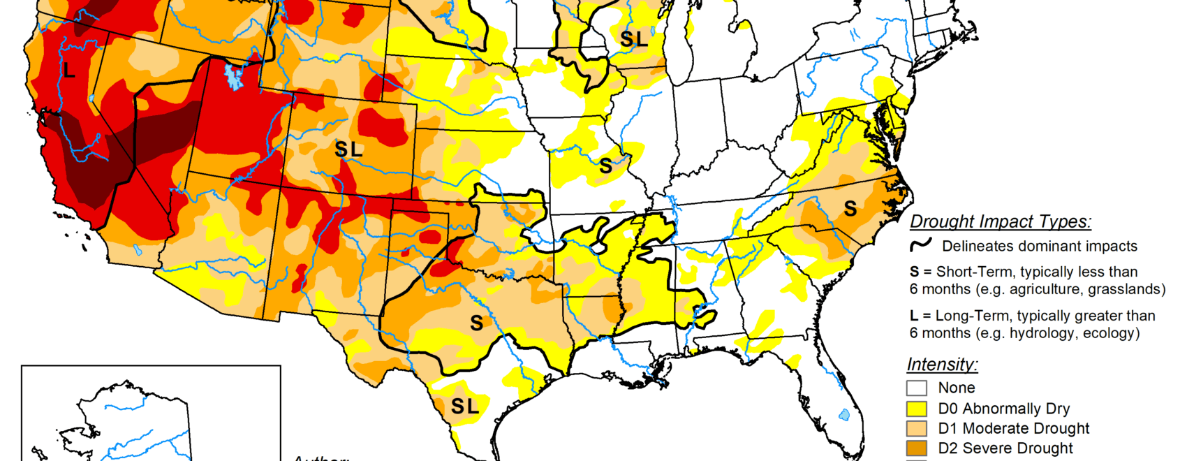
South
Based on worsening soil moisture conditions and recent warmth and enhanced winds, severe drought (D2) was expanded to include all of the Oklahoma Panhandle and this D2 expansion included the northeast Texas Panhandle. Extreme drought (D3) increased across southwestern Oklahoma where a few locations have received less than 0.10 inch of precipitation during the past 70 days. As of December 21, no measurable precipitation has been recorded at Amarillo, Texas for 70 consecutive days which is the 4th longest streak on record. Abnormal dryness (D0) and D1 to D2 drought continue to expand across west-central Texas. Month-to-date temperatures (Dec 1-20) have averaged 6 to 10 degrees F above normal throughout Texas. Impacts, related to the expanding and worsening drought conditions across the southern Great Plains, include poor grazing for livestock. Farther to the east, moderate to heavy rainfall (1 to 3 inches, locally more) resulted in a 1-category improvement to parts of Arkansas, Louisiana, eastern Oklahoma, and eastern Texas. Despite the recent rainfall, 60 to 90-day SPI values continue to support D0 and D1 across eastern Texas and northern Louisiana. Moderate to heavy rainfall (1 to 3 inches) prompted a decrease in the abnormal dryness (D0) for parts of western Tennessee and northern Mississippi.