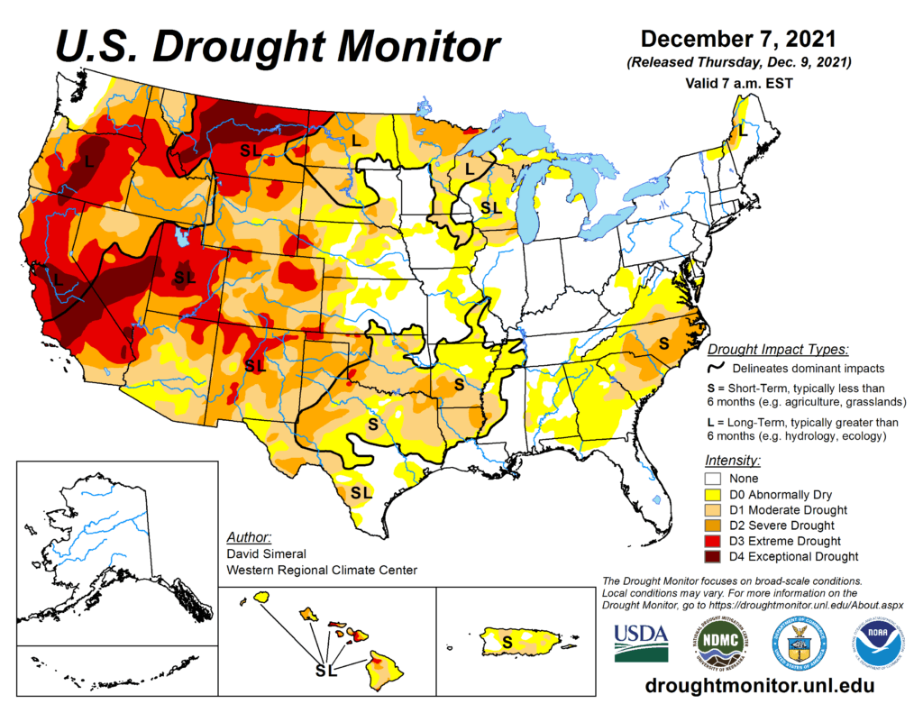
This Week’s Drought Summary
This U.S. Drought Monitor (USDM) week saw continued deterioration in conditions across areas of the Mid-Atlantic (Virginia, North Carolina) and the Southeast (South Carolina, Georgia) in response to below-normal precipitation (past 30- to 90-day period), declining soil moisture and streamflow levels. Likewise, drought-affected areas expanded and intensified on the map in areas of the South including Louisiana, Arkansas, and Texas as well as in the Southern Plains of Oklahoma, where overall warm and dry conditions have prevailed during the past 30- to 120-day period. Across areas of the Northern Plains, Upper Midwest, and the Northeast, light-to-heavy snowfall accumulations were observed during the past week. The heaviest accumulations (8-18 inches) were centered on northern portions of Minnesota, Wisconsin, and Michigan, while lake-effect snowfall (2 to 8 inches) impacted areas downwind of Lake Erie and Lake Ontario in New York, according to snowfall analysis from the National Weather Service (NWS) National Operational Hydrologic Remote Sensing Center (NOHRSC). Out West, some areas including the North Cascades, Sierra Nevada, and the Northern and Central Rockies, received much-needed snowfall this past week. However, basin-level snowpack conditions remained below normal across the entire western United States. In Hawaii, a Kona Low delivered very heavy rainfall accumulations (highest totals exceeding 16+ inches) leading to widespread flooding, power outages, and damage to infrastructure in areas across the Hawaiian Island this week. Impacts from the multi-day event led Hawaii Governor Ige to declare a state of emergency on December 6. With the meteorological autumn (September-November) coming to a close, the Lower 48 experienced its third warmest fall on record with the largest mean temperature departures from average observed across areas of the Northern and Central Plains, according to NOAA’s National Centers for Environmental Information (NCEI). In terms of fall precipitation, the driest conditions were observed across parts of the Southwest, Texas, Montana, Wisconsin, and the Carolinas.
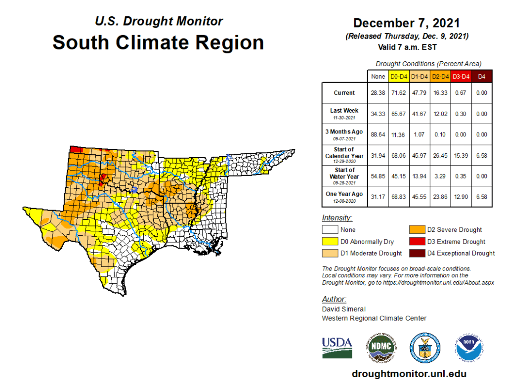
South
For the week, the region was mainly dry with average temperatures that were well above normal (6 to 15 deg F). Some light precipitation (1 to 2 inches) was observed in areas of central Louisiana, Mississippi, and western Tennessee. On the map, conditions degraded across much of the region including Texas, Oklahoma, Louisiana, and Arkansas where areas of Moderate Drought (D1) and Severe Drought (D2) expanded in response to persistent warm and dry conditions. In the western portions of Oklahoma and Texas, the NASA Crop-CASMA application is showing significant negative soil moisture anomalies this month. In the Rolling Plains of Texas, some drought-related impacts have been reported, including reports of winter wheat crops continuing to struggle due to the lack of moisture.