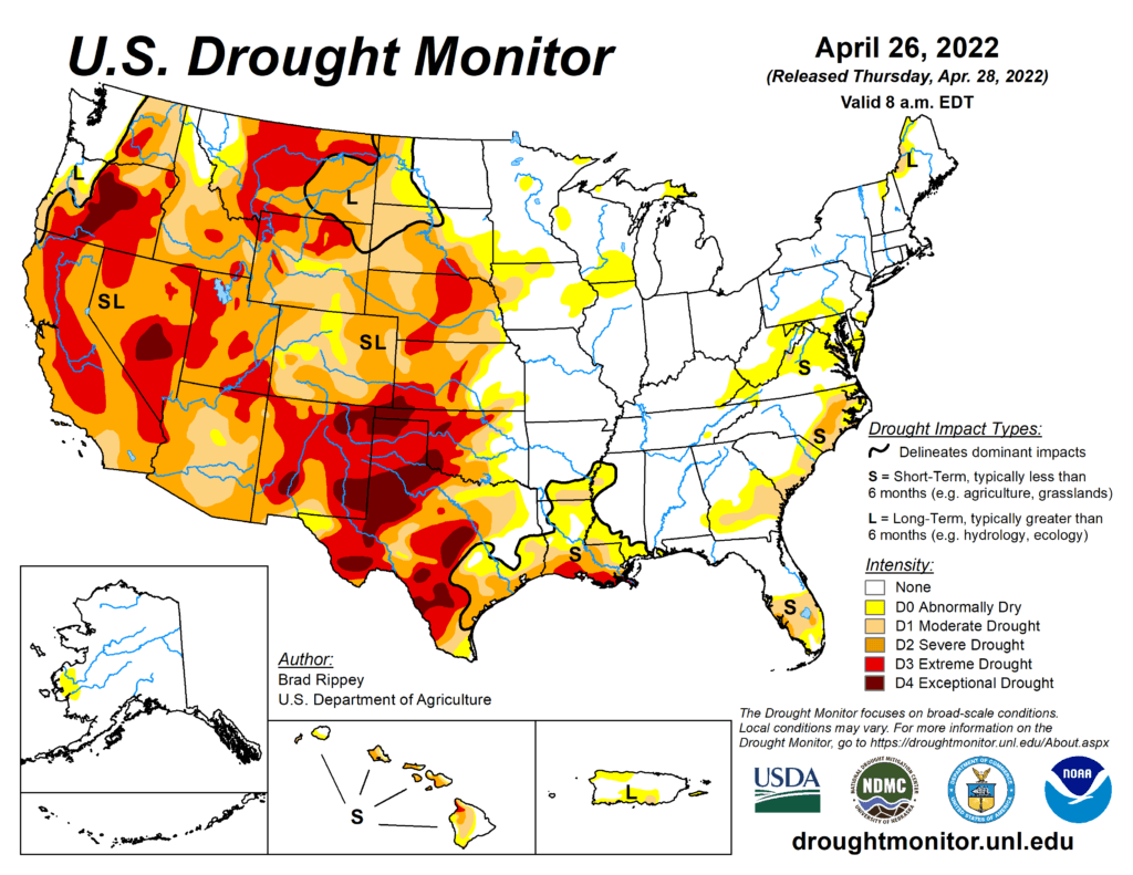
This Week’s Drought Summary
Only about 10 days after a powerful, winter-like storm struck the northern Plains, a similar system delivered another round of heavy precipitation and high winds. With the more recent storm, which primarily unfolded on April 22-23, heavy snow was focused across a smaller area, primarily blanketing western North Dakota, southeastern Montana, northwestern South Dakota, and portions of Wyoming. Meanwhile in the Red River Valley, heavy rain falling on partially frozen soils resulted in extensive flooding, especially north of Fargo, North Dakota, with runoff further enhanced by melting snow. Farther south, high winds again raked the central and southern Plains and the Southwest, resulting in blowing dust and fast-spreading wildfires. Across the southern High Plains’ hardest-hit drought areas, hot, windy weather sapped any remaining soil moisture and further stressed rangeland, pastures, and winter grains. Meanwhile, a few severe thunderstorms dotted the Plains and upper Midwest, leading to localized wind and hail damage. The greatest concentration of severe weather occurred on April 22 from South Dakota to northern Texas. In contrast, little or no precipitation fell during the week across the nation’s southwestern quadrant, leading to further drought intensification. As the drought-monitoring period ended (on the morning of April 26), a significant rain event was winding down across parts of southern and eastern Texas.

South
The region remained split between critically dry conditions on the High Plains of Oklahoma and Texas and wet conditions just to the east. During the drought-monitoring period, the axis of heaviest rain stretched from northeastern Texas into northern Arkansas, with additional rainfall maxima in parts of southern and eastern Texas. Those rains led to targeted, one-category improvements in the drought depiction, with highly localized two-category changes. Meanwhile, the region’s driest areas continued to experience deteriorating conditions, including a broad expansion of exceptional drought (D4), amid periods of extreme heat, high winds, and blowing dust. Temperatures reached 100°F—mainly on April 20 and 21—in parts of the south-central U.S., extending to the Texas-Oklahoma border near Childress (100°F on April 21) and Wichita Falls, Texas (99°F on April 20). In western Texas, peak gusts April 22 were clocked to 73 mph in Lubbock and Dalhart. On April 24, Texas led the country in several drought-related categories, according to the U.S. Department of Agriculture, including topsoil moisture rated very short to short (86%, tied with New Mexico) and winter wheat rated in very poor to poor condition (78%). On the same date, nearly half (48%) of Oklahoma’s wheat was rated very poor to poor.
