This Week’s Drought Summary
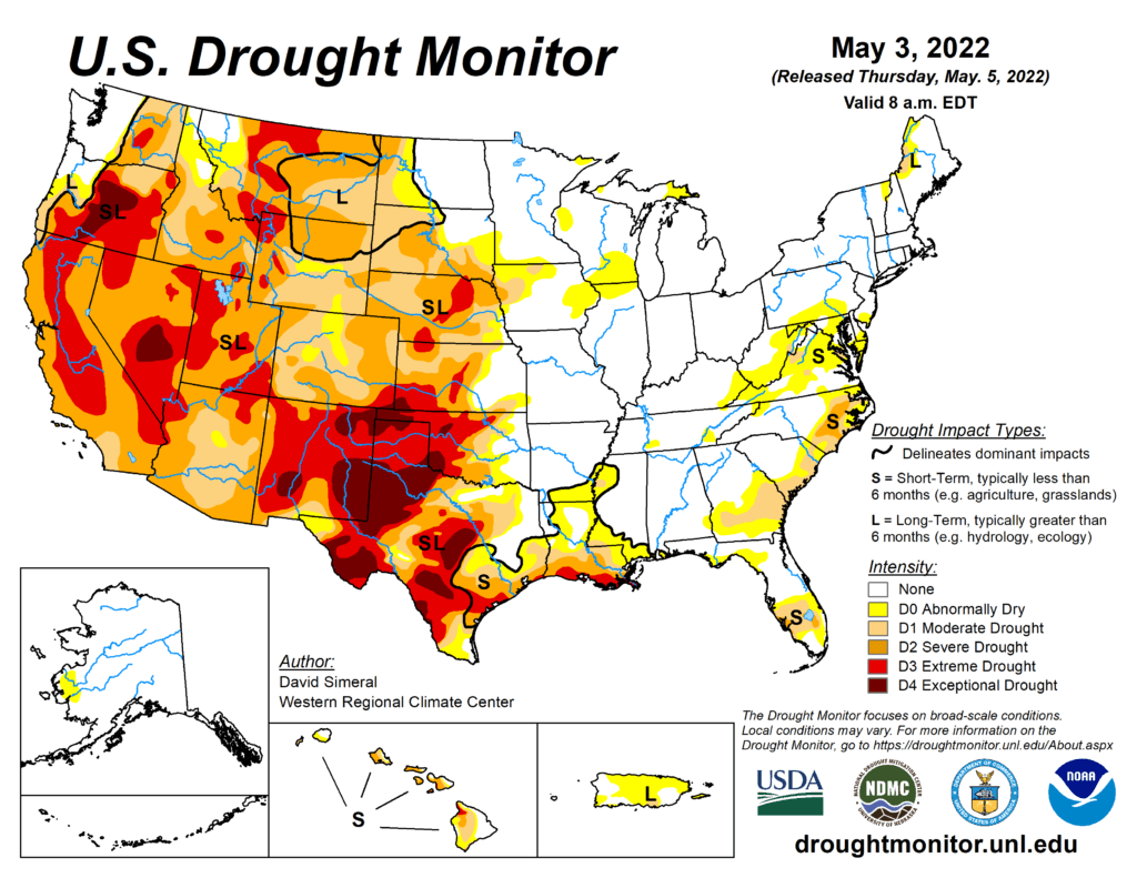
This U.S. Drought Monitor (USDM) week was marked by ongoing active weather across areas of the conterminous U.S. including the Pacific Northwest, Northern Rockies, Plains, Lower Midwest, and isolated areas of the South and Southeast. The most severe weather was observed across the Central Plains and areas of the Midwest where numerous tornadoes touched down in areas including eastern Kansas, southeastern Nebraska, and northern Illinois. Widespread heavy rainfall accumulations were also observed, ranging from 2 to 7 inches, with the heaviest accumulations in eastern Nebraska. The rainfall events provided much-needed moisture to the region-boosting soil moisture levels across parched areas from Kansas to South Dakota. In the West, fast-moving storm systems delivered late season high-elevation snowfall to the Cascades of northern Oregon and Washington, the Northern and Central Rockies, and areas of the northern Great Basin. The highest snowfall totals (8 to 12+ inches) were observed in the Salmon River Mountains of Idaho, the Ruby Mountains of northeastern Nevada, and the Wind River Range of Wyoming. In California and the Southwest, conditions were dry during the past week with strong winds observed across the region. The windy, dry conditions exacerbated fire-weather conditions in Arizona and New Mexico where several large early-season wildfires are currently impacting the region. In northern New Mexico, the Hermits Peak Fire, situated east of Santa Fe in the Sangre de Cristo Mountains, has burned 147,909 acres and is only 20% contained (May 4), according to the National Interagency Coordination Center. On the water-resource front, the Colorado River Basin water situation continues to deteriorate due to the long-term impacts of drought with water levels at Lake Powell and Lake Mead currently at 24% full and 31% full, respectively. With Lake Powell’s water surface elevation currently at 3,522 feet, it is quickly approaching the 3,490-foot threshold level at which Glen Canyon Dam can continue to generate hydropower. The U.S. Bureau of Reclamation (USBR) announced (May 3) two urgent drought response actions to help bolster water levels at Lake Powell. The plan includes additional upstream releases from the Flaming Gorge Reservoir (~500,000 acre-feet [kaf] of water) as well as reducing Glen Canyon Dam’s annual release volume from 7.48-million acre-feet to 7 million acre-feet. In terms of this week’s map, short-term precipitation led to targeted improvements in the Pacific Northwest, Central Plains, South, and the Southeast, while degradations were registered in the Southwest, Texas, Southeast, and the Mid-Atlantic.
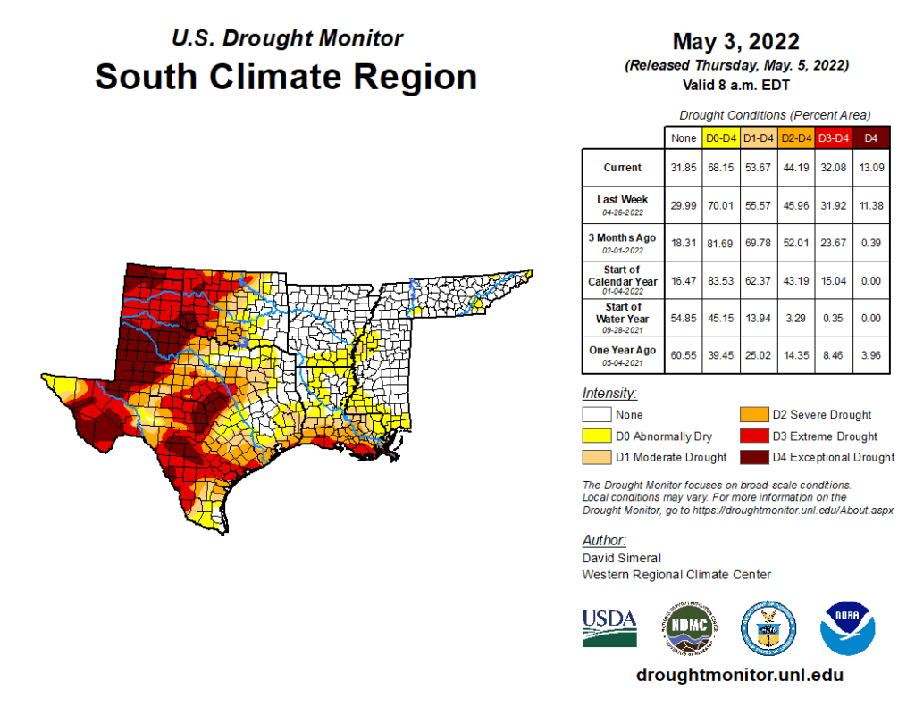
South
In the South, conditions on the map were a mixed bag of improvements and degradations. In southern Louisiana, isolated areas of light-to-moderate rainfall (2 to 4 inches) improved areas of Moderate Drought (D1), Severe Drought (D2), and Extreme Drought (D3) as well as eliminated pockets of Moderate Drought (D1) in northern Louisiana and southern Arkansas. In areas of Texas (Panhandle, north-central, west-central, Trans-Pecos), isolated bands of heavy rainfall (2 to 4 inches) helped to improve drought-affected areas. Conversely, the combination of above-normal temperatures, dry soils, and increased evaporative demand led to degradation in areas of the Panhandle, southeastern Texas, and the Trans-Pecos. In the Panhandle of Oklahoma, small areas of Exceptional Drought (D4) expanded in response to short-term rainfall deficits. Reports in this area include very poor rangeland conditions and local ranchers having to rely on supplemental feed for cattle. According to the latest USDA Oklahoma Crop Progress and Conditions report (May 2), wheat crop conditions were rated 51% poor to very poor and soil moisture was 63% short to very short. For the week, average temperatures were mostly above normal (2 to 8+ deg F) with the greatest positive anomalies observed across Texas and western Oklahoma.