This Week’s Drought Summary
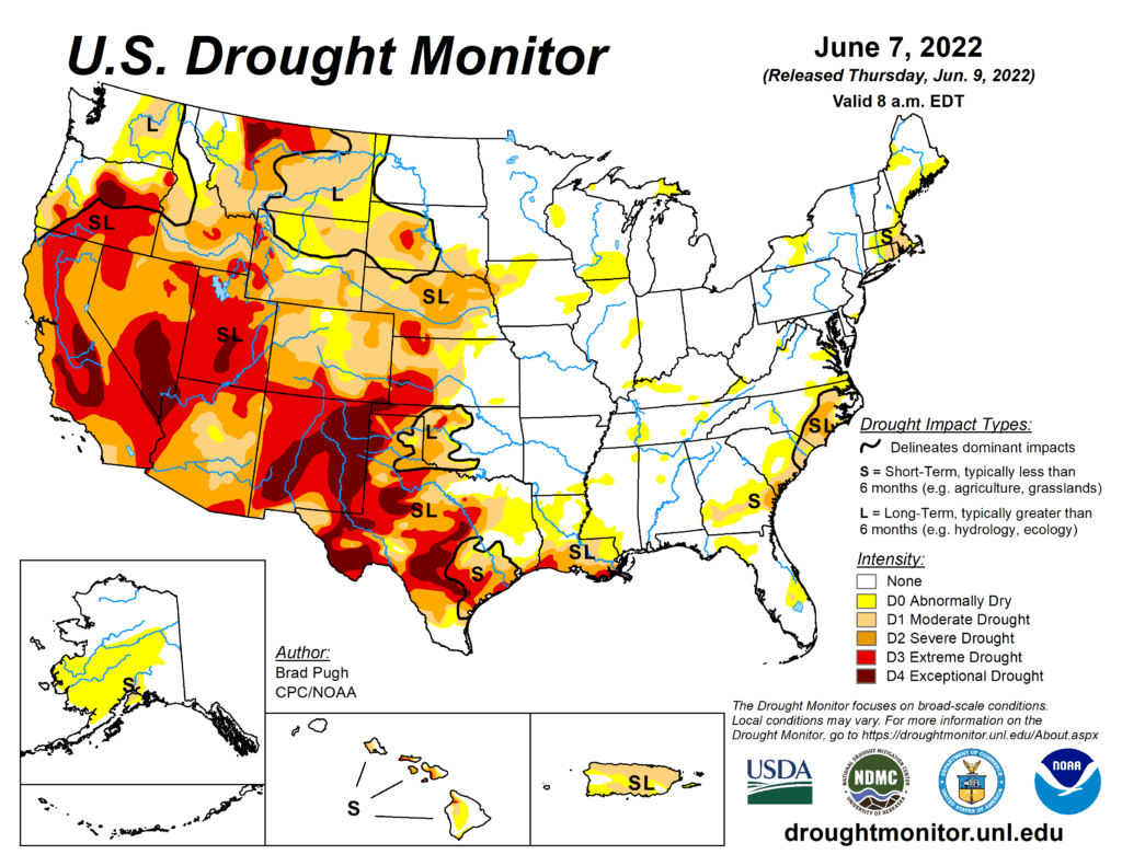
A slow-moving cold front resulted in thunderstorms with heavy rainfall (locally more than 3 inches) across the central to southern Great Plains, lower Mississippi Valley, and the Ozarks Region from May 31 to June 2. As this front progressed eastward, locally heavy rain also fell across the Ohio Valley and Northeast. Mid-level low pressure, which has persisted over the northeastern Pacific through much of the spring, continued to enhance onshore flow and precipitation from the Pacific Northwest eastward to the northern Rockies. 7-day precipitation amounts from May 31 to June 6 exceeded 0.5 inches (locally 2 inches or more) over a broad spatial area of Oregon, Washington, Idaho, Montana, and northern Wyoming. After Hurricane Agatha made landfall on the southern coast of Mexico, its remnant low pressure system tracked northeast to the Yucatan Peninsula and reemerged over the southern Gulf of Mexico. This low pressure system, which became Tropical Storm Alex, brought more than 5 inches of rainfall to southern Florida and triggered flooding in Miami. Seasonal dryness prevailed across southern California and the Desert Southwest. 7-day temperatures, from May 31 to June 6, averaged above-normal across much of the eastern and southern tier of the U.S., while cooler-than-normal temperatures prevailed throughout the northern to central Great Plains and upper Mississippi Valley. Mostly dry weather was accompanied by above-normal temperatures across Alaska during late May into the beginning of June. Trade wind showers brought beneficial wetness to the Big Island of Hawaii. Short-term precipitation deficits continue to increase across Puerto Rico, following another drier-than-normal week.

South
Heavy rainfall (1.5 to 3 inches, locally more) resulted in a 1-category improvement to west-central OK and northwestern TX, setting up a tight west to east gradient in Dx categories. In areas such as Custer County in western Oklahoma, that locally received as much as 8 inches of rainfall during the past week, a 2-category improvement was justified. This heavy rainfall extended southward into southeastern New Mexico and western Texas where parts of the Permian Basin, Davis Mountains, and Big Bend received more than 2 inches at the beginning of June. Farther to the east across parts of central and eastern Texas, along with northwestern Louisiana, increasing short-term precipitation deficits (2 to 4 inches), above-normal temperatures, and higher evapotranspiration rates resulted in a 1-category degradation. This expansion of abnormal dryness (D0) was supported by 30 to 60-day SPEI and these areas stand out on the EDDI product for flash drought. Eastern Texas and northern Louisiana will have to be closely monitored in subsequent weeks as short-term drought could rapidly develop. Locally heavy rain (more than 1 inch) this past week resulted in a slight decrease in D0 for northeastern Louisiana. On June 6, heavy rainfall extended south of the Ohio River which led to a general decrease in the small areas of D0 in Tennessee.